
... the advantages of inspection and survey with thermal imaging camera ...
Increase Productivity
Reduced field time and detection
Results
Careful
Certificate Report
ISO 9712
Do not
Invasive
Less Risks
Operational
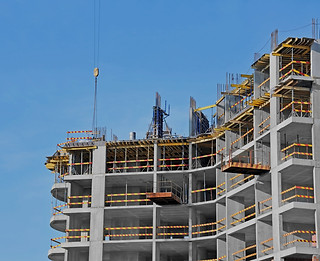
The drone thermography allows to carry out precise and reliable thermal analyzes from a privileged point of view. This technique is used in the AEC sectors (Architecture, Engineering, Construction) from the energy and structural control of plants and buildings, to applications in the environmental field.
SECTORS OF USE

BUILDING

INDUSTRY


INFRASTRUCTURE

POWER
Why choose us
We have been working with UAVs (Drones) since 2014 using the latest generation of thermal imaging cameras;
Ground survey also with handheld thermal imaging camera;
We provide a clear and precise estimate on the intervention methods and reports provided;
We have the best UAVs on the market;
Competence, professionalism and speed in carrying out the survey;
Detailed reports using georeferenced radiometric thermal images;
Certified personnel with ENac certificate for critical area STS-01 and STS-02 compliant with the European regulation;
UAVs certified by Enac and insured up to € 3,000,000:
UNI EN ISO 9712: 2012 Level II certified personnel and RINA RC / C14 regulation in the INFRARED THERMOGRAPHY method of:
II industrial plants,
C civil and artistic heritage,
And ecology,
Ap civil protection

WHICH UAS WE USE
DJI Matrice 300 RTK
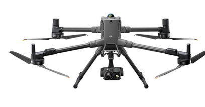
Latest drone born in DJI, a world leader manufacturer in the sector for companies, the main features are:
Flight autonomy up to 1H ;
Take-off weight based on installed PayLoads max 9kg;
Room dedicated to the flight for the pilot;
Possibility of installing several PayLoads at the same time ;
360 ° anti -collision obstacle system;
RTH Return to automatic take-off point;
ADS-B system to identify and warn of the presence of other aircraft;
Navigation lights and stroboscopic daytime and night position visible up to 3km;
Possibility of dual operator, pilot and payLoad operator;
All this sums up the most reliable and versatile remotely piloted aircraft ever produced to date for highly complex inspections and surveys.

Termocamera DJI H30T
La nuova termocamera multi-sensore di punta per sistemi UAS DJI, progettata per operare in qualsiasi condizione ambientale. Le caratteristiche sono:
-
Sensore termico 1280×1024 px DFOV 45,2°, radiometrico Sensibilità termica elevata per analisi avanzate
-
Fotocamera grandangolare CMOS 1/1,3”, 48 MP
-
Zoom ottico fino a 34x, zoom digitale fino a 400x
-
Telemetro laser - Distanza di funzionamento: 3–3000 m
-
Luce NIR ausiliaria per operazioni in condizioni di scarsa illuminazione
-
Sistema multi-sensore integrato: grandangolo, zoom, termico, laser e NIR
L’unica soluzione multi-sensore DJI di nuova generazione che integra termico e visibile simultaneamente, migliorando drasticamente la capacità di rilevamento in scenari complessi.
Grazie agli algoritmi intelligenti di ultima generazione, permette un’elaborazione avanzata delle immagini, rendendole immediatamente utilizzabili per analisi tecniche tramite software dedicati.
Questo consente di creare e restituire report precisi e dettagliati, con doppia visualizzazione termica e ottica, facilitando l’individuazione e l’intervento sulle anomalie riscontrate.

Termocamera FLIR T1030SC
-
Sensore termico 1024×768 px, microbolometro FPA non raffreddato, Pitch sensore: 17 µm
-
Banda spettrale 7,5 – 14 µm
-
Ottica ad alte prestazioni con apertura f/1.15
-
Sensibilità termica (NETD) < 20 mK @ 30°C, Rilevamento estremamente preciso delle minime variazioni di temperatura
-
Frame rate 30 Hz (full frame), Fino a 120 Hz su camera e 240 Hz con HSI su PC (½ immagine)
-
Messa a fuoco: manuale o a impulso (trigger)
-
IR lens, 28° FOV, 36 mm
-
IR lens, 12° FOV, 83.4 mm
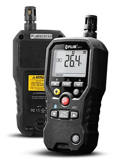
MR77 Misuratore di umidità 5-in-1 con METERLiNK
-
FLIR MR77 integra tutti i sensori di cui hai bisogno per il risanamento danni da acqua o di ispezione dei sistemi di climatizzazione: un sensore di umidità senza puntale e sonda a puntale, un sensore di temperatura e di umidità relativa e un termometro IR. Il misuratore supporta anche Bluetooth®, per la visualizzazione in remoto e la condivisione, nonchè la tecnologia METERLiNK®, per incorporare in modalità wireless le letture nelle immagini termiche radiometriche acquisite con una termocamera FLIR compatibile.
FIELDS OF APPLICATION


Construction and Infrastructures
Phenomena of infiltration, humidity and detachment ...
In the building field, thermal images allow for the distinct identification of beams, slabs, masonry infill and the presence of defects and anomalies such as structural damage, water infiltration under flooring, conditions of humidity or mold, stone detachment on the facade, insulation defects, loss of underground pipes such as district heating, gas / steam pipes, etc.
Non Invasive Inspection
Another possibility is the identification of the wall structure of a building, as well as of thermal bridges and construction elements hidden under the plaster, in a totally non-invasive way . This type of analysis is particularly useful in the case of restorations and renovations .
Evaluation of district heating plants
Drone thermography is also used to check insulation, water infiltration, energy losses on pipes , district heating systems, tunnel linings, road pavements, etc.
Photovoltaic systems
Research and Identification of Anomalies
Identifying the anomalies and the so-called hotspots of a large photovoltaic park is not a simple and fast operation, but with the innovative means in our possession we are able to analyze in a much faster and more efficient way several MW of plants per day.
Large-scale inspections of photovoltaic parks
with the aid of a drone with thermal imaging camera and particular innovative automatic flight techniques, large-scale systems can be inspected in a much shorter time than with a ground-based thermal imaging camera. Depending on the customer's needs, geo-referenced thermographic radiometric maps can be obtained to greatly facilitate the analysis / report task and consequently maintenance intervention.
Non-invasive inspection of roofing systems
with the thermal imager mounted on the drone there is no risk of damaging the system due to trampling of the panels. The thermographic operator positions himself in the safety area on the ground remotely and monitors the system through the images received from the drone.


Plant Analysis
Revamping of photovoltaic systems
Before carrying out maintenance and modernization interventions, it is necessary to compare the projects at your disposal with the actual state of the system . With the innovative survey methods with drone it is possible to detect several MW of photovoltaic systems with countless advantages:
shorter survey times in the field, only one technician is able to detect about 8 MW of plant per day.
complete thermographic map radiometric and geo-referenced in order to know the entity and the exact location of the anomaly.
complete 3D mapping to have the actual state of the plant with an updated floor plan.
greater accuracy of the analysis conducted and report verified by images as realistic proof.
Pre-Project Analysis and Evaluations
To conduct an accurate pre-design analysis, aerial photogrammetry allows you to digitize the territory with incomparable results in terms of speed, accuracy and integration into CAD and BIM systems.


Complete and detailed data
with an automatic survey process it is possible to detect large surfaces and complex structures while maintaining extremely high standards of precision and detail unthinkable before today.
2D IR data
Thermal / Visible Radiometric and Georeferenced Orthomosaic
the results obtained, with a thermal photogrammetry survey with drone, make it possible to analyze larger and more complex systems, guaranteeing higher standards of accuracy and efficiency than surveys with traditional methods with a handheld thermal imaging camera on the ground.
Visible orthomosaic
Photogrammetry allows to eliminate the perspective deformations present in the photographs, to obtain geometrically correct two-dimensional orthophotos. Mosaicing the orthophotos together, the Orthomosaic of an extended area is built, on which measurements can be made with centimeter accuracy.
Thermal Orthomosaic
By changing the type of camera from visible to infrared, it is possible to obtain information relating to the temperature while maintaining the radiometric index present on each individual photo. This allows us to analyze large and complex photovoltaic systems in the best possible way ensuring accuracy and efficiency of the analysis performed.


REQUEST ADVICE ED
A TAILOR-MADE QUOTE

AprFlyTech has specialized for years in the field of surveys, mapping and inspections with thermal imaging cameras and offers an in-depth technical consultancy service. All operations with UAS are in line with the Italian and European ENAC provisions 2019/947. Personnel specialized in thermography with decades of experience and certified level II UNI EN ISO 9712: 2012 and the RINA RC / C14 regulation in the INFRARED THERMOGRAPHY method.
