... the advantages of aerial inspection with drone ...
Greater Productivity
Speed of intervention and analysis
Precise Results
and Accurate

Less Risks
Operational
Remote magnification up to 32x

Intervention not
invasive
SECTORS OF USE


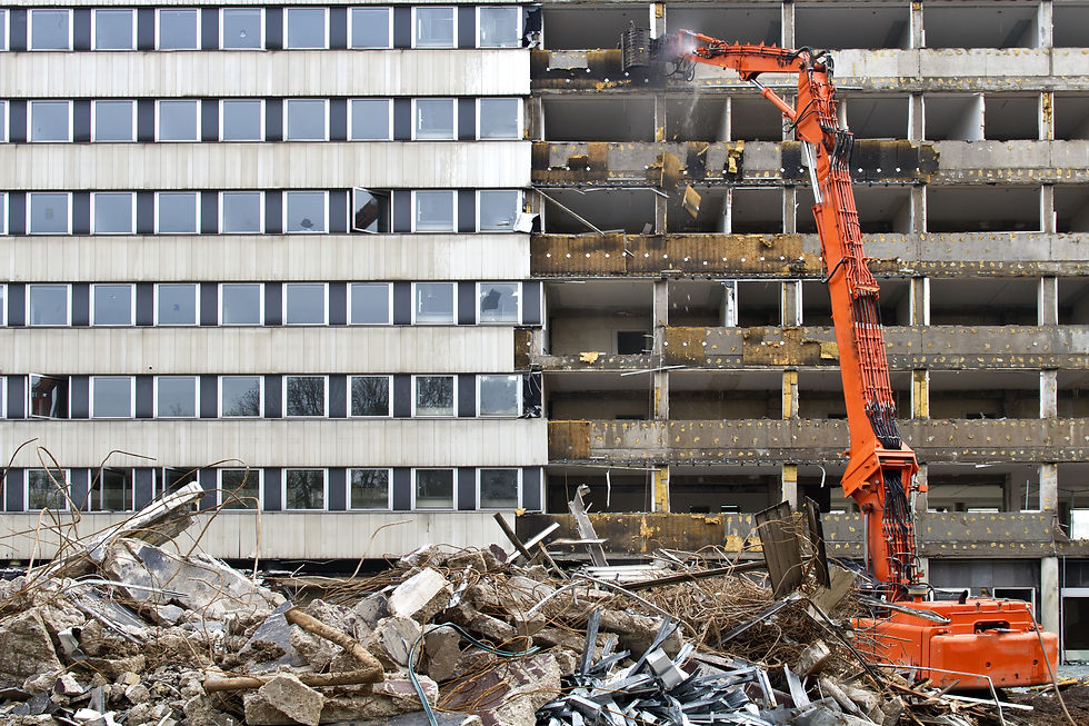
BUILDING

POWER


INFRASTRUCTURE

INDUSTRY
INSPECTION SERVICES
Industrial Plant Inspections
Visual Analysis
Perform an accurate and in-depth analysis of the entire structure using very high definition photographic material and magnification.
Remote operations
operators do not need support scaffolding or hydraulic means to conduct the inspection. No risk due to rope and scaffolding systems, operators drive the drone from a position outside the danger zones.
Speed of intervention
our specialized operators for flights in critical areas can intervene in shorter and faster times in situations where the assembly of a particular support structure would be required.
Short or no plant downtime
Unlike manual inspections in which plant shutdown is often used due to the presence of operators in the field, with the drone in most cases there is no need to interrupt the normal function of the machines.


Roof and Roof Inspections
Industrial roofing, warehouses and warehouses
Perform an accurate and in-depth analysis of the entire structure using very high definition photographic material and magnification.
Roofs of condominium and residential buildings
with a 3D photogrammetry survey the results obtained offer a much higher quantity of data than the surveys with traditional methods.


Census Photovoltaic systems
Serial codes for photovoltaic panels
Each photovoltaic panel installed has a unique serial identification code that makes it identifiable.
According to the current legislation, each panel installed must also be associated with the position of the panel and the corresponding code on the installation project.
This data is sometimes not updated correctly during panel replacement or maintenance .
We offer a review and census service of all the codes present on the plant with aerial inspections with drone :
non-invasive , so as not to damage the implant.
not dangerous for operators.
less prone to errors and revisable via photos.


River Bridge Inspections
Video inspections with ROVs and boats
Perform an accurate and in-depth analysis of the entire structure using very high definition photographic material and magnification.
Roofs of condominium and residential buildings
with a 3D photogrammetry survey the results obtained offer a much higher quantity of data than the surveys with traditional methods.

APRFT vessel
Specially designed for video inspections of canals and river bridges:
Avoid the intervention and immersion of inspectors
Possibility of installing different detection tools;
Allow to inspect decks only 60cm high from the water;
Navigation lights and lighting for low light situations;
Unlimited autonomy with quick battery change;
WHO WE ARE

Why choose us
We have been working with UAVs (Drones) since 2014 using the latest generation of thermal imaging cameras;
Ground survey also with handheld thermal imaging camera;
We provide a clear and precise estimate on the intervention methods and reports provided;
300 RTK matrix with Hexagon Leica Geosystem network correction;
Competence, professionalism and speed in carrying out the survey;
Return with accuracy up to 1 cm + 1 ppm (horizontal) 1.5 cm + 1 ppm (vertical) with flight in RTK;
Pix4D certified staff for processing and return;
Lidar DJI L1 for complex surveys and large surfaces with vegetation with a high vertical accuracy of 5 cm /
horizontal 10 cm at 100m flight height, at 50m a forecast of 3 / 5cm is obtainedWe use GNSS antennas with an accuracy ranging from 1 to 2 cm with a typographic support relief
Certified personnel with ENac certificate for critical area STS-01 and STS-02 compliant with the European regulation;
UAVs certified by Enac and insured up to € 3,000,000:
OUR MEANS
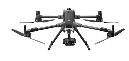
DJI Matrice 300 RTK
Latest drone born in DJI, a world leader manufacturer in the sector for companies, the main features are:
Flight autonomy up to 1H ;
Take-off weight based on installed PayLoads max 9kg;
Room dedicated to the flight for the pilot;
Possibility of installing several PayLoads at the same time ;
360 ° anti -collision obstacle system;
RTH Return to automatic take-off point;
ADS-B system to identify and warn of the presence of other aircraft;
Navigation lights and stroboscopic daytime and night position visible up to 3km;
Possibility of dual operator, pilot and payLoad operator;
All this sums up the most reliable and versatile remotely piloted aircraft ever produced to date for highly complex inspections and surveys.
DJI P1 Full Frame Camera
Latest Full Frame camera born in DJI, the main features are:
45MP full-frame sensor;
Pixel size from 4.4 μm;
Thanks to the full-frame, high-sensitivity low-noise sensor that can take a photo every 0.7s during flight and cover 3km2 in a single flight
TimeSync 2.0 aligns the camera, flight controller, RTK module and gimbal at the microsecond level;
Optics 35 and 24mm with precision without GCP 3 cm horizontally 5 cm vertically;
Pixel size (GSD) ranges from 0.8cm to 1.5cm;