
The advantages of photogrammetry and drone survey ...
Increase Productivity
Reduced field time and detection
Results
Careful
Integration
CAD and BIM
Updated data
in the Cloud

Less Risks
Operational
SECTORS OF USE


BUILDING


GIS


INFRASTRUCTURE

INDUSTRY


EXTRACTION

POWER
Why choose us
We have been working with UAVs (Drones) since 2014 using the latest generation of thermal imaging cameras;
Ground survey also with handheld thermal imaging camera;
We provide a clear and precise estimate on the intervention methods and reports provided;
300 RTK matrix with Hexagon Leica Geosystem network correction;
Competence, professionalism and speed in carrying out the survey;
Return with accuracy up to 1 cm + 1 ppm (horizontal) 1.5 cm + 1 ppm (vertical) with flight in RTK;
Pix4D certified staff for processing and return;
Lidar DJI L1 for complex surveys and large surfaces with vegetation with a high vertical accuracy of 5 cm /
horizontal 10 cm at 100m flight height, at 50m a forecast of 3 / 5cm is obtainedWe use GNSS antennas with an accuracy ranging from 1 to 2 cm with a topographical support relief
Drivers with ENAC certificate for critical area
ENAC certified drones for standard scenarios STS-01 and STS-02 compliant with the European "SPECIFIC" regulation;
UAVs certified by Enac and insured up to € 3,000,000:

WHAT WE USE
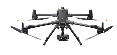
DJI Matrice 300 RTK
Latest drone born in DJI, a world leader manufacturer in the sector for companies, the main features are:
Flight autonomy up to 1H ;
Take-off weight based on installed PayLoads max 9kg;
Room dedicated to the flight for the pilot;
Possibility of installing several PayLoads at the same time ;
360 ° anti -collision obstacle system;
RTH Return to automatic take-off point;
ADS-B system to identify and warn of the presence of other aircraft;
Navigation lights and stroboscopic daytime and night position visible up to 3km;
Possibility of dual operator, pilot and payLoad operator;
All this sums up the most reliable and versatile remotely piloted aircraft ever produced to date for highly complex inspections and surveys.
DJI P1 Full Frame Camera
Latest Full Frame camera born in DJI, the main features are:
45MP full-frame sensor;
Pixel size from 4.4 μm;
Thanks to the full-frame, high-sensitivity low-noise sensor that can take a photo every 0.7s during flight and cover 3km2 in a single flight
TimeSync 2.0 aligns the camera, flight controller, RTK module and gimbal at the microsecond level;
Optics 35 and 24mm with precision without GCP 3 cm horizontally 5 cm vertically;
Pixel size (GSD) ranges from 0.8cm to 1.5cm;


.jpg)
DJI P1 Full Frame Camera
Latest Full Frame camera born in DJI, the main features are:
45MP full-frame sensor;
Pixel size from 4.4 μm;
Thanks to the full-frame, high-sensitivity low-noise sensor that can take a photo every 0.7s during flight and cover 3km2 in a single flight
TimeSync 2.0 aligns the camera, flight controller, RTK module and gimbal at the microsecond level;
Optics 35 and 24mm with precision without GCP 3 cm horizontally 5 cm vertically;
Pixel size (GSD) ranges from 0.8cm to 1.5cm;
DJI L1 Lidar
The Zenmuse L1 includes a Livox Lidar module, a high-precision IMU and a camera with a 1 "CMOS sensor on a 3-axis stabilized gimbal.
Livox Lidar module
Lidar framing with up to 100% effective point cloud results
Detection range: 450m (80% remission, 0 klx) / 190m (10% remission, 100 klx)
Effective point rate: 240,000 points / s
It supports 3 scan returns
Non-repetitive scan pattern or Repetitive scan pattern
1 "sensor, 20MP, mechanical shutter

Unprecedented precision
It renders accurate reconstructions down to the centimeter thanks to the high-precision IMU, a vision sensor for positioning accuracy and the incorporation of GNSS data.
Extraordinary efficiency
Generate point cloud models with true color or acquire 2km2 of data in point clouds in a single flight thanks to the Lidar module with Livox frame, FOV of 70 ° FOV and a light visible camera with 1 "sensor.
.jpg)
Unprecedented precision
It renders accurate reconstructions down to the centimeter thanks to the high-precision IMU, a vision sensor for positioning accuracy and the incorporation of GNSS data.

Challenges in architectural engineering
The lack of accurate location data makes aligning BIM projects, road vector maps and satellite imagery difficult, costing both time and manpower.
2D designs cannot illustrate the spatial information needed to fully visualize the design.
BIM projects can be very different from the reality model, making it difficult to visualize and verify the project.

How drones power architectural engineering
Create 3D models with accurate positioning data that can easily be inserted into BIM models to visualize designs.
Designs can be optimized using 3D models created by drones compatible with a variety of GIS software.


THE RESULTS
Complete and detailed data
with an automatic survey process it is possible to detect large surfaces and complex structures while maintaining extremely high standards of precision and detail unthinkable before today.
Data 2 D
Orthomosaic, Digital Terrain Model (DTM) and Contours, Elevation Planes ...
the results obtained, with a photogrammetry survey with drone, offer a much higher amount of data and information than surveys with traditional methods
Orthomosaic
Photogrammetry allows to eliminate the perspective deformations present in the photographs, to obtain geometrically correct two-dimensional orthophotos. Mosaicing the orthophotos together, the Orthomosaic of an extended area is built, on which measurements can be made with centimeter accuracy.
Digital Terrain / Surface Models
The ground can be represented with Digital Surface Models (DSM), which indicate altimetric variations. Furthermore, if you are not interested in evaluating objects on the ground, such as trees or buildings, we can obtain Digital Terrain Models (DTM) that reproduce the real course of the terrain. Each product can be supplied with representations in various color scales and contour lines.
ALCUNI DEI NOSTRI ULTIMI RILIEVI:
Autodromo di Monza (125ha)
Colgate SPA stabilimento (75ha)
Tangenziale Est Milano (3,5km)
SS Telesina Benevento (25km / 1200ha)
Nexans SPA (40 ha)
Ponte Cave RM


Survey and Monitoring
Reduced acquisition times in the field
Creation of 3D and 2D models with fast image acquisition using drones or laser scanners.
More complete and reliable results
with a 3D photogrammetry survey the results obtained offer a much higher quantity of data than the surveys with traditional methods.
With an acquisition, everything that is inside the survey space is detected without having to return to the field to integrate anything else.
Regular and repeatable survey
setting of the automated and repeatable survey over time for the purpose of comparison for the progress of work or monitoring excavations.
The differences found between the elaborations carried out in subsequent times can prove to be fundamental not only for working with constantly updated data but also for highlighting any critical issues.
Work in the cloud
quick and easy chronological comparison on a specially developed cloud platform.


Complete and detailed data
with an automatic survey process it is possible to detect large surfaces and complex structures while maintaining extremely high standards of precision and detail unthinkable before today.
Data 2 D
Orthomosaic, Digital Terrain Model (DTM) and Contours, Elevation Planes ...
the results obtained, with a photogrammetry survey with drone, offer a much higher amount of data and information than surveys with traditional methods
Orthomosaic
Photogrammetry allows to eliminate the perspective deformations present in the photographs, to obtain geometrically correct two-dimensional orthophotos. Mosaicing the orthophotos together, the Orthomosaic of an extended area is built, on which measurements can be made with centimeter accuracy.
Digital Terrain / Surface Models
The ground can be represented with Digital Surface Models (DSM), which indicate altimetric variations. Furthermore, if you are not interested in evaluating objects on the ground, such as trees or buildings, we can obtain Digital Terrain Models (DTM) that reproduce the real course of the terrain. Each product can be supplied with representations in various color scales and contour lines.


Survey and Monitoring
Reduced acquisition times in the field
Creation of 3D and 2D models with fast image acquisition using drones or laser scanners.
More complete and reliable results
with a 3D photogrammetry survey the results obtained offer a much higher quantity of data than the surveys with traditional methods.
With an acquisition, everything that is inside the survey space is detected without having to return to the field to integrate anything else.
Regular and repeatable survey
setting of the automated and repeatable survey over time for the purpose of comparison for the progress of work or monitoring excavations.
The differences found between the elaborations carried out in subsequent times can prove to be fundamental not only for working with constantly updated data but also for highlighting any critical issues.
Work in the cloud
quick and easy chronological comparison on a specially developed cloud platform.


3D Virtual Inspections
Safer and more performing
Do not let staff take avoidable risks, use more performing and faster UAV machines and remote tools.
Photogrammetric digitization
aerial photogrammetry makes it possible to quickly and automatically digitize most of the plants, excavations, buildings and infrastructures in the area in 2D and 3D environments.
Fast and accurate
possibility of georeferencing data and quickly measuring results using particular 3D programs or in CAD and BIM environments.
Work in the cloud
inspections accessible and carried out in the cloud without having to download any data that is too large.
Cloud management of inspections with "before and after" historical comparisons.
Complete and detailed data
with an automatic survey process it is possible to detect large surfaces and complex structures while maintaining extremely high standards of precision and detail unthinkable before today.
Data 2 D
Orthomosaic, Digital Terrain Model (DTM) and Contours, Elevation Planes ...
the results obtained, with a photogrammetry survey with drone, offer a much higher amount of data and information than surveys with traditional methods
Orthomosaic
Photogrammetry allows to eliminate the perspective deformations present in the photographs, to obtain geometrically correct two-dimensional orthophotos. Mosaicing the orthophotos together, the Orthomosaic of an extended area is built, on which measurements can be made with centimeter accuracy.
Digital Terrain / Surface Models
The ground can be represented with Digital Surface Models (DSM), which indicate altimetric variations. Furthermore, if you are not interested in evaluating objects on the ground, such as trees or buildings, we can obtain Digital Terrain Models (DTM) that reproduce the real course of the terrain. Each product can be supplied with representations in various color scales and contour lines.


Data 3 D
Point Cloud and Solid with Photographic Texture
with an automatic survey process it is possible to detect large surfaces and complex structures while maintaining extremely high standards of precision and detail, unthinkable before today.
Cloud of Points
Depending on the level of detail required, we generate Point Clouds that provide a representation of the context and the object of the assignment in detail .
The Cloud is made up of a vast set of points (even hundreds of millions) with a precise location in 3D space. This allows you to import the point cloud into specific CAD or BIM programs to take advantage of all the shape and size information they contain.
Solid with photographic texture
Each point of the cloud is used as a vertex for the creation of a solid polygonal jersey.
It is a set of vertices, edges and faces that define the shape and size of the object.
Distance measurements can be made on this model, perimeters, areas and volumes . For a better graphic result the solid is superimposed on a realistic photographic Texture of the actual state of the object of the survey.


Sections and Altimetric Profiles
From each three-dimensional model we extract sections and elevation profiles according to needs. To obtain a better graphic feedback, the sections are accompanied by the relative Point Clouds.
Each product derived from the photogrammetric process can be exactly constrained in space, through the acquisition of the coordinates of Support Points detected with GPS or Total Station instrumentation.
In the event that georeferencing is not of primary interest, it is still possible to assign a correct Scale value to each model, in order to size the site or object investigated.
TEST
RTK
View the report
Drone: DJI Matrice 300 RTK
Camera: Zenmuse P1 - 35mm
Internal image parameters: active
Points to the ground: 15 verification only
Number of Images: 224
Average Flight Altitude: 103m
Medium Resolution (GSD): 1.21cm / pix
XY error ( RMSE ): 1.35cm
Z error ( RMSE ): 6.70 cm
Average error ( RMSE ): 6.83cm
GCP
View the report
Drone: DJI Matrice 300 RTK
Camera: Zenmuse P1 - 35mm
Internal image parameters: disabled
Points to the ground: 11 check 4 check
Number of Images: 224
Average Flight Altitude: 103m
Medium Resolution (GSD): 1.21cm / pix
XY error ( RMSE ): 1.30cm
Z error ( RMSE ): 1.02 cm
Average error ( RMSE ): 1.65cm
PPK
View the report
Drone: DJI Matrice 300 RTK
Camera: Zenmuse P1 - 35mm
Internal image parameters: active
Points to the ground: 15 verification only
Number of Images: 224
Average Flight Altitude: 103m
Medium Resolution (GSD): 1.26cm / pix
XY error ( RMSE ): 1.43 cm
Z error ( RMSE ): 1.12 cm
Average error ( RMSE ): 1.82cm
Conclusions
From the tests carried out, it can therefore be deduced that the DJI M300 system combined with DJI Zenmuse P1 with RTK correction returns results with an accuracy (RMSE) of about 1.5 cm horizontally. and about 5 / 7cm vertically .
An excellent result for an RTK system that allows you to achieve results equal to the survey with only GCP, by adding only few (3/5) ground reference marker to correct the results.
To achieve even higher levels of accuracy and without the use of GCP, you can use with M300 RTK, the method of Post Processing Kinematic called PPK.
Using the PPK method it is possible to increase the vertical accuracy (RMSE) up to 1.12cm without affixing any marker to the ground, otherwise for error verification.
An absolutely stunning achievement for the DJI M300 RTK system.

